How to use this website
Taxa
There are two ways of accessing the information in the database: either by searching (see next section) or by browsing through the taxa. Click on a taxon name to see the subtaxa (Order > Family > Genus > Species), then click on the looking glass  to see the details of that specific taxon.
Search
The search page offers three options:
- Basic search - identical to the taxonomy section of the Advanced search
- Advanced search - explained here
- Blast - explained in the section Blast
Taxonomy
Choose a name in of one the drop-down menus to search for a certain taxon. Selecting a value will automatically restrict the options in the other select-boxes, e.g. selecting Beamys as genus, will automatically restrict the family to Nesomyidae, the order to Rodentia, and the species to hindei and major. Click reset to search for a new name.
Distributions & Ecology
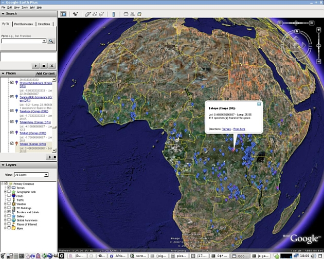
Here you can query on country, locality, latitude, longitude, habitat and gender. Latitude and longitude have to be entered in decimal degrees. You can also define an area by drawing a polygon on the map: click the draw-icon  , define the borders of your preferred area and close by clicking the starting point
  . If you want to move the map during drawing, click the move-icon
  . Start over by clicking the cancel-icon
  .
.
You can also restrict your search to specimens from a certain habitat. As we define ‘near water’ as a habitat, it is clear that it wasn’t our aim to use 'habitat' in a very strict manner in the context of this website. ‘Buildings, roads, etc.’ comprises different habitats associated with humans.
Specimen information
This section allows queries on more detailed information, such as collector, determinator and collection date.
You can specify the basis of record of the specimens included in your search (by default all options are included):
 Preserved (specimen): A specimen physically available in our collections, and defined by a valid RMCA / RBINS-specimen number, like: RMCA 96.037-M-3796.
 Observation: A specimen observed in the field. If this specimen was collected/preserved, it is in the process of getting a valid RMCA / RBINS-specimen number (and becoming 'preserved').
 Ghost: A specimen from another museum, of which we hold some data (like measurements or sequences).
You also have the possibility to restrict your search to type specimens, measured (external or craniometrical measurements), sequenced and photographed specimens. Other characteristics to limit the search are the accuracy of determination, the availability of information on the sexual condition and sample- and test-information.
Note that all the above sections can be used independently and together. This means you can search on all specimens found in Tanzania (Distributions & Ecology) and on all specimens from the genus Mus in Tanzania (Taxonomy combined with Distributions & Ecology).
Search results
The results of your search are divided in three different sections:
Taxa
The taxa lists shows all the taxa that correspond to your search criteria. You can sort the results by clicking the header of any column. Click the taxon name if you want to see a detailed page about the taxon. For each taxon the number of specimens found with your criteria is indicated in the column 'Found', and the total number of specimens for that taxon is indicated in the column 'Total'. If the specimens that meet your criteria include type, photographed and sequenced specimens, this will be indicated by the icons in the 'Specimens'-column. The icons in the 'Taxon'-column show you if a species description and/or literature is available.
Specimens
To see the specimens which correspond to your search criteria in a table, click 'Show specimens table'. Just like in the taxa-table, you can sort the results by clicking the header of any column. Click on the looking glass to see a detailed page about the specimen. The icons give you an overview on what information is available for a specimen: if the specimen is georeferenced, photographed, sequenced or a type-specimen.
Click 'Show specimens on a map' to see a Google Map of the georeferenced specimens which correspond to your search criteria.
Exports
The export section gives you the opportunity to export your search results and save them on your computer for further use. Results are exported in the csv file format, which is a file type that stores tabular data. This file format is very simple and supported by almost all spreadsheets (Excel, ...) and database management systems (Access, PostgreSQL, ...).
You can export your search results as a very detailed specimen list or as a kml-file, which will show all the georeferenced specimens in Google Earth, sorted per taxon. You can also download all the (external and craniometrical) measurements for the measured and all the sequences for the sequenced specimens in your search. The exports are also available on each taxon page, where you can export all the results for that taxon.
The export section is only available for registered users, but registration is free of charge.
Exports
The CSV file format is a file type that stores tabular data. This file format is very simple and supported by almost all spreadsheets (Excel, ...) and database management systems (Access, PostgreSQL, ...). Data are encoded in the Unicode UTF-8 character set. Be sure to select this encoding when you import data in your software (Excel, ...). Exports are generated "on the fly" and can take some time to load.
Important: In Openoffice Calc, Microsoft Excel 97, Microsoft Excel 2000, Microsoft Excel 2002, and Microsoft Office Excel 2003, text files that contain more than 65536 rows cannot be opened in their entirety. You cannot open these files because these spreadsheets are limited to 65536 rows. If you open a file that contains more data than this, the text file is truncated at the row 65536, and you receive the following error message: "File not loaded completely". Check http://support.microsoft.com/kb/120596 for a solution, or split the file.
